No Result
View All Result
AerialFire
  • Articles
    • Columns
    • Cover Stories
    • Drone/UAS
    • Feature Stories
    • Fire Regulations
    • Government
    • Ground Ops
    • Helicopter
    • International Operations
    • LAT
    • Press Release
    • Retardant
    • SEATs
    • Technology
    • VLAT
    • Wildfire
  • Store
  • Current Issue
  • Contact Us
Subscribe
AerialFire
No Result
View All Result
Home Aerial Fire News

Shoot From the Stars: Startup Provides Early Detection of Wildfires From Space

by AerialFire Staff
October 1, 2021
in Aerial Fire News, Technology
Reading Time: 2 mins read
Shoot From the Stars: Startup Provides Early Detection of Wildfires From Space

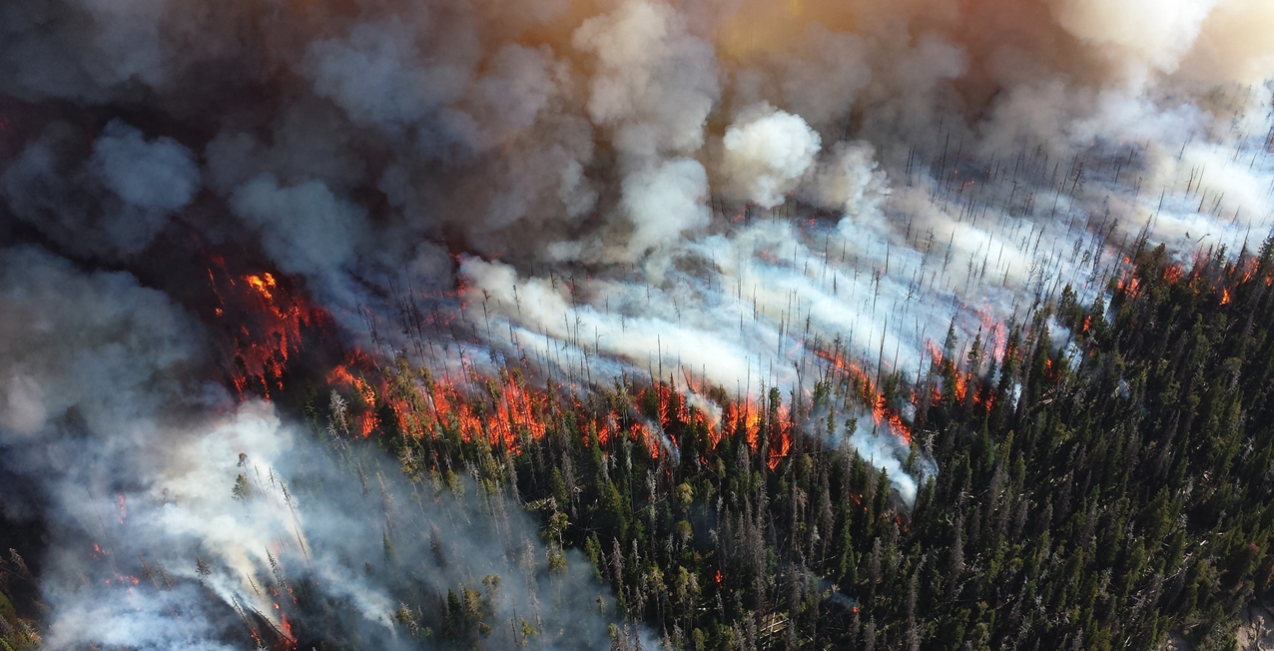
Wildfires are responsible for about 6 percent of the planet’s CO2 emissions, according to Earth System Science Data. Australia’s bushfire season of 2019-2020 alone saw over 46 million acres of land devastated by wildfire, including the loss of almost half a billion mammals, birds and reptiles.

NVIDIA Inception member OroraTech is addressing these issues head-on with its wildfire detection and monitoring service.

Combining data from predominantly satellites but also ground-based cameras, aerial observations and local weather information, the Munich-based startup is taking on the challenge of preventing one of today’s most prevalent disasters.

“Wildfires are a natural phenomenon — but global warming is making it worse,” said Björn Stoffers, one of the company’s co-founders. “There are more droughts, pest infestation, higher temperatures and humans are building houses in wildfire-prone areas. Our goal is to monitor wildfires around the world and detect every fire within 30 minutes.”

Detection From Start to Finish

Data suggests global warming might be happening faster than we thought. Temperatures are rising, carbon dioxide levels are at their highest and extreme weather events are happening more frequently. Preventing wildfires is one route to reducing a sizable chunk of CO2 emissions, not to mention saving lives and property.

OroraTech provides risk assessment features to help monitor areas before wildfires can appear. Its holistic approach analyzes a fire risk index, wind particle layers, and the greenness of vegetation and moisture levels to highlight vulnerable areas where a potential wildfire can easily spread.

Early detection and real-time monitoring are used during an active wildfire. Using imagery from 19 satellites and many ground-based cameras, the company’s system can detect wildfires even in remote areas and then present visuals of the area and fire progression over time.

In Mozambique’s Niassa Special Reserve, the Wildlife Conservation Society has already put OroraTech’s system to good use. Wildfire alerts enabled rangers to prevent a base camp from burning down with only 100 meters between the camp and the blaze.

The system also provides damage analysis to review air pollution, fire origin and burned area after a wildfire has taken place.

Read more on this story at Oratech

Tags: Aerial FirefightingTEchnology

AerialFire Staff

AerialFire Magazine strives to provide you with breaking aerial firefighting industry news and information.

Related Posts

TBM 960 Aircraft Deploys for First Wildfire Season

TBM 960 Aircraft Deploys for First Wildfire Season

by AerialFire Staff
May 28, 2025

ABBOTSFORD, CANADA (May 27, 2025) – Conair Group Inc. (Conair) has deployed two Daher TBM 960 Air Attack aircraft for...

Entrol Strengthens Pilot Training with the Delivery of S-64 FTD Level 6 Simulator to Korea Forest Aviation Headquarters

Entrol Strengthens Pilot Training with the Delivery of S-64 FTD Level 6 Simulator to Korea Forest Aviation Headquarters

by AerialFire Staff
May 27, 2025

● Simulator based on the complex S-64E helicopter, designed for specialized firefighting training. ● Equipped with complete ENWALL LED technology,...

Tabula and Plane Finder Partner to Deliver ADS-B In Capability for Enhanced Cockpit Awareness

Tabula and Plane Finder Partner to Deliver ADS-B In Capability for Enhanced Cockpit Awareness

by AerialFire Staff
May 23, 2025

Mosgiel, NZ, May 23, 2025 - Tabula, a leading provider of job management and fleet tracking solutions for aerial operations, has...

Avincis Secures Firefighting Contracts in Spain for 14 Aircraft

Avincis Secures Firefighting Contracts in Spain for 14 Aircraft

by AerialFire Staff
May 22, 2025

ALICANTE, Spain – May 22, 2025: Avincis, Europe’s leading provider of emergency aerial services, has been awarded new wildfire response...

Trending News

No Content Available
TBM 960 Aircraft Deploys for First Wildfire Season
Press Release

TBM 960 Aircraft Deploys for First Wildfire Season

by AerialFire Staff
May 28, 2025
Entrol Strengthens Pilot Training with the Delivery of S-64 FTD Level 6 Simulator to Korea Forest Aviation Headquarters
Aerial Fire News

Entrol Strengthens Pilot Training with the Delivery of S-64 FTD Level 6 Simulator to Korea Forest Aviation Headquarters

by AerialFire Staff
May 27, 2025
Tabula and Plane Finder Partner to Deliver ADS-B In Capability for Enhanced Cockpit Awareness
Aerial Fire News

Tabula and Plane Finder Partner to Deliver ADS-B In Capability for Enhanced Cockpit Awareness

by AerialFire Staff
May 23, 2025
Avincis Secures Firefighting Contracts in Spain for 14 Aircraft
International Operations

Avincis Secures Firefighting Contracts in Spain for 14 Aircraft

by AerialFire Staff
May 22, 2025
AerialFire

© 2025 AerialFire, a Marsayl Media Publication. All rights Reserved.

Navigate Site

  • Privacy Policy
  • Terms of Service
  • Advertise With Us
  • Contact Us

Follow Us

No Result
View All Result
  • Home
  • Subscribe
  • Store
  • Current Issue
  • Advertise With Us
  • Contact Us

© 2025 AerialFire, a Marsayl Media Publication. All rights Reserved.

Skip to content
Open toolbar Accessibility Tools

Accessibility Tools

  • Increase TextIncrease Text
  • Decrease TextDecrease Text
  • GrayscaleGrayscale
  • High ContrastHigh Contrast
  • Negative ContrastNegative Contrast
  • Light BackgroundLight Background
  • Links UnderlineLinks Underline
  • Readable FontReadable Font
  • Reset Reset