

Fire crews plan to work through the night to contain the estimated 2,400-acre Wilderness Trail Fire in Crawford County which closed I-75 for much of Saturday.
The fire started around 1 p.m. about 4 miles southeast of Grayling near Staley Lake in Grayling Township.
Among those assisting with the fire are the Michigan State Police, USDA Forest Service, Bureau of Land Management, Grayling Station 2, Grayling Public Safety, the Gaylord City Fire Department and fire departments from Grayling Township, Kalkaska, Blue Lake, Beaver Creek, Markey Township, Higgins Township, Richfield Township, South Branch Township, Frederic Township, Otsego County, Cold Springs and Denton Township fire departments are assisting with the fire.
Ground crews, heavy equipment, a Michigan State Police helicopter, and four USDA Forest Service fire boss planes and a Type 1 helicopter also have been assigned to help suppress the fire.
The fire cause is not yet available.
Evacuation and safety information
The Red Cross has been activated to assist people evacuated from the area. Shelter is available at Beaver Creek Township Hall, 8888 S. Grayling Road.
The wildfire has produced an abundance of smoke. Visibility may be reduced on roadways – drive with care in affected areas. Limit exposure to wildfire smoke by staying indoors with windows shut, especially if you have asthma or another respiratory condition.
Closures and flight restrictions
Previously closed sections of I-75 between 4 Mile Road (exit 251) to North Down River Road (exit 256) are now open. Please check MiDrive for the most up-to-date information on road closings. Remaining closures:
- Staley Lake Road from M-72 to 4 Mile Road is closed.
- Wilderness Trail from Keystone Landing Road to Staley Lake Road is closed.
- Staley Lake Beach and Kneff Lake Beach are closed.
A Temporary Flight Restriction is in place for a 5-mile perimeter around the fire at heights below 5,000 feet. Do not fly aircraft or drones in the area.
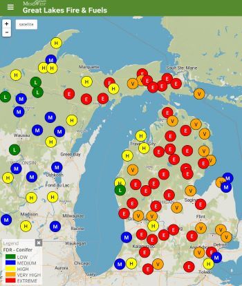
Fire danger is extreme in much of the state
Michigan remains under extreme fire danger conditions following a prolonged stretch of hot and dry weather. Check daily fire danger conditions on the Great Lakes Fire and Fuels map.
The DNR recommends these actions to reduce the risk of wildfire:
- Never leave a fire unattended, even for a moment.
- Check first to see if conditions permit open burning at Michigan.gov/BurnPermit.
- Always put fires out completely with water. Drench, stir with a shovel and drench again.
- Don’t park hot equipment over dry grass on the roadside, which can ignite.
- More information is available at Michigan.gov/PreventWildfires.
The DNR will continue to share fire updates via news releases and on the department Twitter account at Twitter.com/MichiganDNR.
