

INTRODUCTION
As Australia braces itself for the Spring 2023 season, the stage seems set for a period of heightened vigilance and preparedness in terms of bushfire outlook. The shift in Australia’s climatic influences since last spring has brought the nation under the spotlight of increased bushfire risk. A majority of the regions are expecting above-average temperatures and below-average rainfall, a concoction that typically spells increased fire activity.
Moreover, the previous La Niña years have led to an upsurge in fuel growth in many regions, further escalating the risk of bushfires. Communities across various states and territories are urged to ramp up their preparations and closely monitor the local conditions as the spring unfolds.
Understanding the seasonal bushfire outlook becomes pivotal as it outlines the potential fire threats in various regions, assisting in strategic planning and community awareness. The outlook is not a prediction of where and when bushfires will occur, but a tool to identify areas of increased risk, helping communities to be primed for appropriate action.
As a leader in the firefighting and aviation data industry, TracPlus recognises the importance of understanding the complex factors that contribute to fire risks. With our extensive experience and commitment to supporting wildfire response efforts, we’re pleased to offer an analysis of the latest long-range forecast just released by the Bureau of Meteorology. This article aims to provide valuable insights into the expected weather conditions and their implications for the upcoming 2023/2024 fire season across Australia’s diverse regions.
NATIONWIDE OVERVIEW
As we venture into Spring of 2023, it is paramount to grasp the climatic intricacies that influence Australia’s bushfire outlook. This season, the key climatic influences shaping Australia’s weather patterns and consequently the bushfire outlook, are the developments in the El Niño–Southern Oscillation (ENSO) and the Indian Ocean Dipole (IOD).
Both the BoM and AFAC have noted significant shifts in the climatic patterns compared to the last year, mainly driven by the transition from La Niña to a probable El Niño phase. This transition is expected to have a substantial influence on the weather conditions across Australia, altering the rainfall patterns and temperature trends.
The ENSO Alert: A Signal to Prepare
The El Niño-Southern Oscillation (ENSO) currently retains a neutral stance, with neither La Niña nor El Niño dominating the scene. However, a subtle yet significant shift is underway. The tropical Pacific ocean waters have been gradually warming since the beginning of 2023, breaching the El Niño thresholds. Despite the ocean showing signs of an impending El Niño, the atmosphere remains in a neutral state, indicating an uncoupled condition that is commonly seen during the onset of El Niño events. As we navigate through this transitional phase, a 70% likelihood of an El Niño emergence lingers, potentially diminishing the winter-spring rainfall in the eastern expanses of Australia, thereby escalating the bushfire risk.
The IOD’s Influence: A Potential Drying Agent
Simultaneously, the Indian Ocean Dipole (IOD), presently neutral, hints at transitioning towards a positive phase in the forthcoming months. According to the BoM, the last three weeks have seen the Indian Ocean Dipole (IOD) index exceed the positive IOD threshold of +0.40 °C. However, several more weeks of positive IOD values above the threshold are needed for greater confidence that a positive IOD event is underway. This shift might act as a drying agent, reducing the winter-spring rainfall particularly in the southern and central belts of Australia, thereby potentially augmenting the fire risk in these regions.
Global Warming: A Persistent Undercurrent
On the global front, an unprecedented surge in sea surface temperatures has been witnessed since April 2023. The warming trend, which reflects a larger narrative of global warming, rings alarm bells for Australia, a nation that has already experienced a temperature uptick of about 1.47 °C from 1910 to 2021. This persistent undercurrent has redefined rainfall patterns, fostering high-intensity, short-duration rain events, especially in the north, while the southern precincts have witnessed a dwindling cool season rainfall, down by 10-20% in recent decades.
![]()
The Evolving Fire Seasons: Adapting to New Normals
Navigating through these changing climes, Australia finds itself adapting to evolving fire seasons characterised by more frequent elevated fire dangers, appearing earlier and lingering longer each year. While the recent La Niña events have provided a respite, a shift in the ENSO state might revert or escalate this trend, ushering in longer and more intense fire seasons. This evolving pattern necessitates heightened vigilance, particularly during the spring and summer months, as dangerous fire weather days have seen a significant upswing, especially in the southern and eastern corridors of Australia.
Temperature Trends Heading into spring, Australia is expected to witness a notable escalation in temperature. The BoM predicts a warmer trajectory for the September to November period, with over an 80% chance of above-median maximum temperatures encompassing nearly the entire country. Moreover, the minimum temperatures are also expected to soar, especially in areas surrounding the Great Australian Bight and extending into the central Northern Territory, indicating warmer nights ahead.
Rainfall Predictions The rainfall patterns during the same period paint a rather dry picture. Northern Australia, extending from the Kimberley region in WA to Queensland, and southern parts encompassing regions from southern WA to the Riverina region in southern NSW are projected to experience below-median rainfall. Particularly, isolated regions in the southwest and southeast might witness significantly reduced rainfall, creating a backdrop for increased bushfire activity.
Soil Moisture and Evaporation The combination of reduced rainfall and heightened temperatures is forecasted to create drier than average soil moisture conditions by late spring, particularly impacting the south and east of Australia. This condition, coupled with existing high fuel loads, signifies an enhanced risk of flammability in various regions. It is anticipated that these factors will contribute to a bushfire season characterised by rapid grass fires, necessitating quick responses and heightened aerial reconnaissance to manage the potential threats effectively.
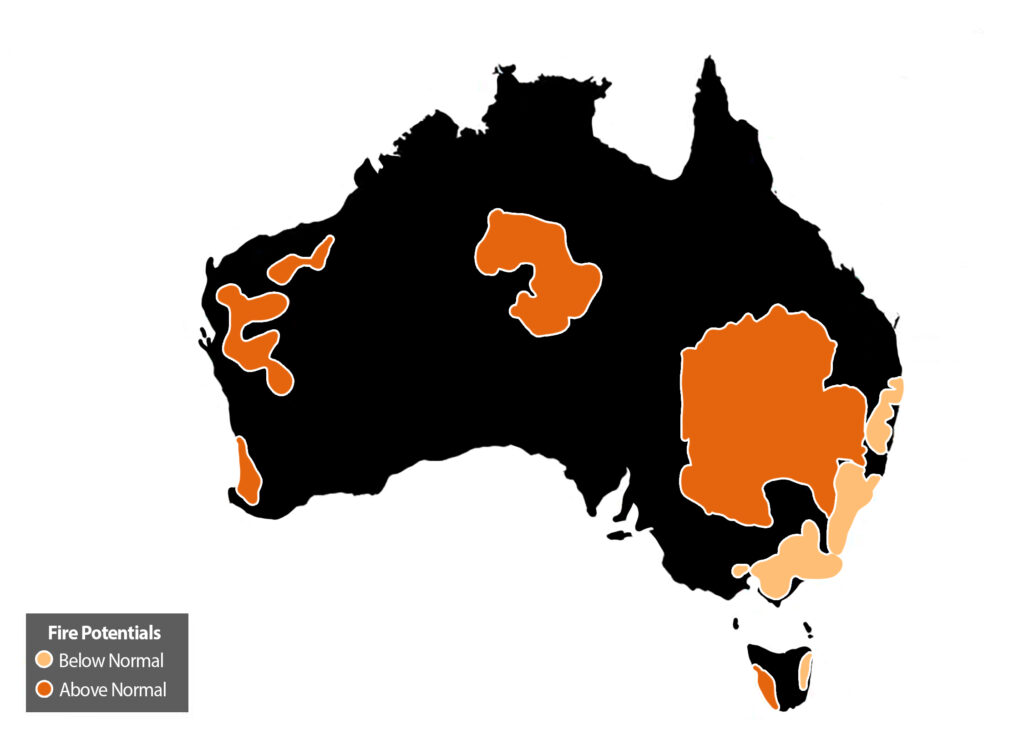
In light of these developments, a detailed analysis of the regional bushfire outlooks becomes essential to understand the varied implications across Australia’s diverse landscapes, assisting communities and firefighting agencies in gearing up for a season that demands vigilance and preparedness.
CONCLUSION:
The Spring 2023 bushfire outlook paints a varied picture across Australia, with several regions bracing for heightened fire risks due to a combination of meteorological factors. From the increased grass fire potential in New South Wales and Victoria to the anticipated intense bushfires in parts of Queensland and South Australia, it is clear that a diverse range of challenges await the firefighting teams across the country.
In this context, TracPlus stands as a reliable partner for firefighting agencies and teams, equipped to offer real-time tracking and operational insights that can significantly bolster wildfire response strategies. Our solutions are designed to be a powerful tool in the hands of those who are tasked with safeguarding communities from the unpredictable and often devastating impact of bushfires.
As we navigate this season, aerial firefighting strategies in Australia will need to be meticulously orchestrated to mitigate the potential risks effectively. The pronounced grass growth due to previous La Niña seasons necessitates a focus on preventing and controlling grass fires, which tend to spread rapidly and can be highly unpredictable. Aerial assets might be leveraged more for swift initial attack capabilities to prevent small fires from becoming uncontrolled, especially in regions with high grass fuel loads. Moreover, the intelligence gathered through aerial reconnaissance will be pivotal in mapping the spread of fires and identifying potential hotspots in the vast grasslands and forested areas.
As the nation gears up to face the potential challenges of the coming months, we at TracPlus are ready to support the teams on the front lines, offering technology-driven solutions that can enhance efficiency and safety during wildfire operations.
