No Result
View All Result
AerialFire
  • Articles
    • Columns
    • Cover Stories
    • Drone/UAS
    • Feature Stories
    • Fire Regulations
    • Government
    • Ground Ops
    • Helicopter
    • International Operations
    • LAT
    • Press Release
    • Retardant
    • SEATs
    • Technology
    • VLAT
    • Wildfire
  • Store
  • Current Issue
  • Contact Us
Subscribe
AerialFire
No Result
View All Result
Home Aerial Fire News

UP42 and OroraTech Facilitate Geospatial Data Access with On-Demand Sensor Tasking

by AerialFire Staff
November 30, 2023
in Aerial Fire News, Drone/UAS, Fire Regulations, Government, Press Release, Technology
Reading Time: 2 mins read
UP42 and OroraTech Facilitate Geospatial Data Access with On-Demand Sensor Tasking

Berlin/Munich, November 30, 2023 – UP42, a geospatial developer platform and marketplace, and OroraTech, the leader in space-based thermal intelligence, have signed a partnership agreement to grant easy and fast access to global high-resolution thermal-infrared imagery. OroraTech delivers low-latency, global coverage, near-real-time thermal data products.

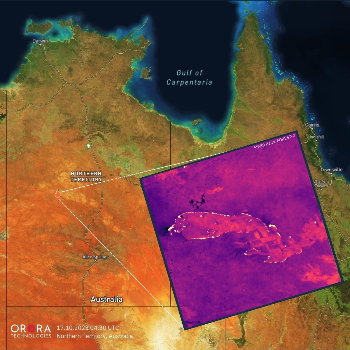
OroraTech, the first of its kind to join UP42's growing marketplace of nearly 80 data and processing partners, provides valuable insights to customers during unpredictable events through its newly launched thermal sensor, FOREST-2. Via UP42’s marketplace, the company offers the following data products:

  • On-demand tasking for near real-time data access from anywhere in the world with 400km coverage and  200m resolution on a daily basis. .
  • Access to an ever growing future archive of thermal imagery for past event analysis.

UP42 tasking allows for  advanced capabilities such as order tracking, automated delivery, and support for complex and multi-geometry AOIs. Furthermore, OroraTech's tasked data is managed in UP42's STAC-compatible storage, simplifying the search and management of data for easier processing and integrations.

"As global temperatures rise, wildfires and heat waves are having an increasing impact on people, the environment, and economies. In 2022 alone, heat waves accounted for 99% of all climate-related deaths in Europe," said Sean Wiid, CEO of UP42, referring to a recent World Meteorological Organization report. "Expanding our offering with OroraTech’s thermal-infrared data will help our customers build early-warning and monitoring systems to help us mitigate the impact of these climate-related emergencies."

OroraTech's high-resolution thermal data serves customers on six continents, ranging from forestry and utility companies to governmental organizations and geospatial experts. Facilitating rapid disaster response, location accuracy, and predictive analytics, its data helps assess risks, minimize losses, and supports 24/7 response measures.

"With UP42 our customers have easy and quick access to our thermal tasking capability," says Axel Roenneke, CCO at OroraTech. "This partnership accelerates our route to the geospatial market."

To learn more about and order OroraTech’s thermal-infrared products via UP42’s marketplace, please visit UP42’s marketplace for On-Demand Tasking and the marketplace for the archive of thermal imagery.

Tags: Aerial FirefightingAerial MApping

AerialFire Staff

AerialFire Magazine strives to provide you with breaking aerial firefighting industry news and information.

Related Posts

Earl Watters: The Firefighter Behind The Chinook Helicopter Boomer

Earl Watters: The Firefighter Behind The Chinook Helicopter Boomer

by AerialFire Staff
May 16, 2025

Firefighter Pilot Shares Videos of Minnesota Wildfire Water Drops Wildfires continue to rage in Northern Minnesota, on pace to be the...

Fire Season Now 12 Months Long, According to CalFire

Fire Season Now 12 Months Long, According to CalFire

by AerialFire Staff
May 14, 2025

CalFire is doing what they can to keep Nevada County and surrounding areas safe during what they are now calling...

Aerial Firefighters in Missoula Gear Up for Wildfire Season

Aerial Firefighters in Missoula Gear Up for Wildfire Season

by AerialFire Staff
May 13, 2025

MISSOULA, Mont. – Neptune Aviation Services, based at the Missoula Montana Airport, is preparing for wildfire season as they continue...

NY National Guard Aircrews Train with Forest Rangers to Prep for Wildfires

NY National Guard Aircrews Train with Forest Rangers to Prep for Wildfires

by AerialFire Staff
May 13, 2025

SCHUYLERVILLE, N.Y. - New York Army National Guard helicopter crews partnered with state Department of Environmental Conservation Forest Rangers to...

Trending News

No Content Available
Earl Watters: The Firefighter Behind The Chinook Helicopter Boomer
Aerial Fire News

Earl Watters: The Firefighter Behind The Chinook Helicopter Boomer

by AerialFire Staff
May 16, 2025
Fire Season Now 12 Months Long, According to CalFire
Aerial Fire News

Fire Season Now 12 Months Long, According to CalFire

by AerialFire Staff
May 14, 2025
Aerial Firefighters in Missoula Gear Up for Wildfire Season
Aerial Fire News

Aerial Firefighters in Missoula Gear Up for Wildfire Season

by AerialFire Staff
May 13, 2025
NY National Guard Aircrews Train with Forest Rangers to Prep for Wildfires
Aerial Fire News

NY National Guard Aircrews Train with Forest Rangers to Prep for Wildfires

by AerialFire Staff
May 13, 2025
AerialFire

© 2025 AerialFire, a Marsayl Media Publication. All rights Reserved.

Navigate Site

  • Privacy Policy
  • Terms of Service
  • Advertise With Us
  • Contact Us

Follow Us

No Result
View All Result
  • Home
  • Subscribe
  • Store
  • Current Issue
  • Advertise With Us
  • Contact Us

© 2025 AerialFire, a Marsayl Media Publication. All rights Reserved.

Skip to content
Open toolbar Accessibility Tools

Accessibility Tools

  • Increase TextIncrease Text
  • Decrease TextDecrease Text
  • GrayscaleGrayscale
  • High ContrastHigh Contrast
  • Negative ContrastNegative Contrast
  • Light BackgroundLight Background
  • Links UnderlineLinks Underline
  • Readable FontReadable Font
  • Reset Reset