No Result
View All Result
AerialFire
  • Articles
    • Columns
    • Cover Stories
    • Drone/UAS
    • Feature Stories
    • Fire Regulations
    • Government
    • Ground Ops
    • Helicopter
    • International Operations
    • LAT
    • Press Release
    • Retardant
    • SEATs
    • Technology
    • VLAT
    • Wildfire
  • Store
  • Current Issue
  • Contact Us
Subscribe
AerialFire
No Result
View All Result
Home Aerial Fire News

UAVOS Deploys UVH 170 Unmanned Helicopter for Wildfire Support

by Ryan Mason
April 10, 2024
in Aerial Fire News, Drone/UAS, Press Release
Reading Time: 2 mins read
UAVOS Deploys UVH 170 Unmanned Helicopter for Wildfire Support

UAVOS has successfully completed its first field deployment supporting wildfire suppression agencies with its UVH 170 unmanned helicopter. In this mission, UAVOS' drone pilots were deployed during the day and also at night to gather timely data for situational awareness, ensuring high-quality data collection. Providing geospatial data in real-time has been a goal in fire mapping.

The UVH 170 unmanned helicopter gathered georeferenced data using visible-light cameras and thermal imaging cameras. The mission results established that the UAVOS' Gimbal 201, which the UVH-170 UAS is equipped with, meets fire service criteria by providing target sensitivity, accuracy, and data delivery based on the needs of fire operations.

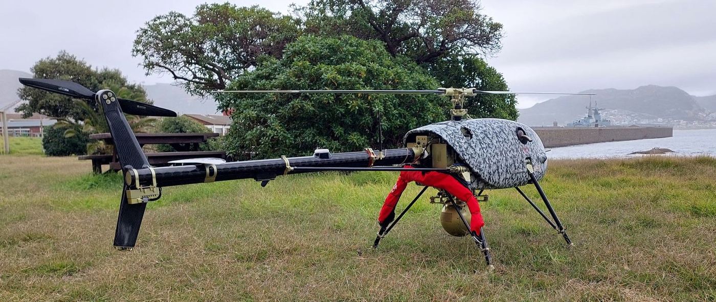
Fully automatic, UAVOS’s UVH 170 helicopter can fly for up to 5 hours and carry payloads that weigh up to 4 kg, including sophisticated sensors for civilian and security purposes. In a wildfire situation, UAVOS pilots fly the UVH 170 UAS two thousand meters above the ground to capture highly accurate video feeds along the fire’s boundaries.

These video feeds are georeferenced live and streamed to the UAS ground control station in real time. Afterwards, data specialists use the video and a special program to interpret the infrared data. By eliminating delays in imagery acquisition, interpretation, transmission, and production, fire personnel can receive updates in real time, enabling informed decision-making when it matters most.

“Operating from a safe distance, a drone pilot can identify and geo-locate hot spots, providing critical information to the fire management team to aid them with planning, resource management, and assigning tasks and priorities for the day. This process is a lot faster and safer than firefighters walking through hazardous terrain surveying the fire line,” - comments UAVOS CEO Aliaksei Stratsilatau.

Tags: Aerial FirefightingDroneUASUAVOS

Ryan Mason

Related Posts

Australian Natural Disaster Responders McDermott Aviation Deploy Aircraft to Greece Ahead of European Fire Season

Australian Natural Disaster Responders McDermott Aviation Deploy Aircraft to Greece Ahead of European Fire Season

by AerialFire Staff
May 19, 2025

Monday 19 May 2025: As the fire season gets underway in Greece, six McDermott Aviation B214 ST aircraft have been deployed...

Earl Watters: The Firefighter Behind The Chinook Helicopter Boomer

Earl Watters: The Firefighter Behind The Chinook Helicopter Boomer

by AerialFire Staff
May 16, 2025

Firefighter Pilot Shares Videos of Minnesota Wildfire Water Drops Wildfires continue to rage in Northern Minnesota, on pace to be the...

Fire Season Now 12 Months Long, According to CalFire

Fire Season Now 12 Months Long, According to CalFire

by AerialFire Staff
May 14, 2025

CalFire is doing what they can to keep Nevada County and surrounding areas safe during what they are now calling...

Aerial Firefighters in Missoula Gear Up for Wildfire Season

Aerial Firefighters in Missoula Gear Up for Wildfire Season

by AerialFire Staff
May 13, 2025

MISSOULA, Mont. – Neptune Aviation Services, based at the Missoula Montana Airport, is preparing for wildfire season as they continue...

Trending News

No Content Available
Australian Natural Disaster Responders McDermott Aviation Deploy Aircraft to Greece Ahead of European Fire Season
Aerial Fire News

Australian Natural Disaster Responders McDermott Aviation Deploy Aircraft to Greece Ahead of European Fire Season

by AerialFire Staff
May 19, 2025
Earl Watters: The Firefighter Behind The Chinook Helicopter Boomer
Aerial Fire News

Earl Watters: The Firefighter Behind The Chinook Helicopter Boomer

by AerialFire Staff
May 16, 2025
Fire Season Now 12 Months Long, According to CalFire
Aerial Fire News

Fire Season Now 12 Months Long, According to CalFire

by AerialFire Staff
May 14, 2025
Aerial Firefighters in Missoula Gear Up for Wildfire Season
Aerial Fire News

Aerial Firefighters in Missoula Gear Up for Wildfire Season

by AerialFire Staff
May 13, 2025
AerialFire

© 2025 AerialFire, a Marsayl Media Publication. All rights Reserved.

Navigate Site

  • Privacy Policy
  • Terms of Service
  • Advertise With Us
  • Contact Us

Follow Us

No Result
View All Result
  • Home
  • Subscribe
  • Store
  • Current Issue
  • Advertise With Us
  • Contact Us

© 2025 AerialFire, a Marsayl Media Publication. All rights Reserved.

Skip to content
Open toolbar Accessibility Tools

Accessibility Tools

  • Increase TextIncrease Text
  • Decrease TextDecrease Text
  • GrayscaleGrayscale
  • High ContrastHigh Contrast
  • Negative ContrastNegative Contrast
  • Light BackgroundLight Background
  • Links UnderlineLinks Underline
  • Readable FontReadable Font
  • Reset Reset